Well, that concludes my list of my favorite places that I have backpacked and would like to go backpacking. As I look back at the list, I realize that alot of them are natural parks. This inspires me to invest in our natural parks because of the opportunities they present for backpackers and outdoor enthusiasts. Alot of these parks may be out of reach for you, financially or physically. I reccomend finding local parks that have unique aspects to them. I wrote about Devils Lake, a local state park near my hometown, in one of my recent posts. I encourage you to share your experiences on this page or in blogs of your own.
Throughout the process of writing this, I have realized that I do not have enough chances to get out and explore the wilderness that I talk about so much. I really enjoy getting out there, but unfortunatley the college life makes that difficult sometime. It seems like weekend trips will be the answer until summer rolls around, then hopefully i'll have the chance to tackle some of the big parks i wrote about throughout this blog. Well, that pretty much sums it up. Until we talk next, have a great time in the outdoors!
Monday, December 8, 2008
Crater Lake, OR

I remember first hearing about Crater Lake back in earth science class during my senior year of high school. It sounded like a great place to go, but I never had the time to go and check it out then. I have looked at the website and it looks like a great place to go backpacking and exploring the unique geological feature. In case you haven't heard of Crater Lake, here are some statistics:
-Depth: 1,943 ft. deep (7th Deepest in the world, Deepest in the United States)
-There is an average of 533 inches of snow per year that keeps the lake full. (No inlet, or outlet).
-It's freshwater is some of the clearest found anywhere.
There are 100 miles of trails in Crater park, with varying levels of difficulty. I think the most important thing to remember when hiking in an area like this is to remember the elevation. The surface of crater lake is about 7000 ft. above sea level. Hiking conditions are much different here if you are used to hiking at only a couple thousand feet above sea level. Allow plenty of time for breaks to stop and drink water or rest. Once you reach the lake, you have a great supply of some of the cleanest water in North America, great for drinking after your hike up.
Because Crater Park is one of the snowiest places in North America, the weather conditions can greatly affect the backpacking conditions. Many of the campsites are open only during a few short months in the summer. It is not unusual to have about 6-8 feet of snow on the ground when spring rolls around. You can check this website to see the closures of the park, and the best times they suggest to visit. If you get a chance to head out to Oregon and see this beautiful park, take some pictures and post them back here, i'd love to hear your experiences!

Thursday, December 4, 2008
Devils Lake State Park, WI

This is a site that I'm really familiar with because it is located only about an hour from my home. Devils Lake State park is an attraction for many outdoor enthusiasts from Wisconsin and surrounding states. The park is in a central location within the state, providing convenient access to those interested in checking it out. I have been to this park a handful of times and really enjoy the beauty, especially in the fall. There are great hiking trails, but not quite as much for the avid backpacker. There are not too many places where backpackers can set up tents and camp alongside trails, we'll have to stick to the designated campsites on this one.

The bluffs around the lake are a challenge to hike and attract many climbers annually who enjoy scaling the great rock faces along the lake. This blog is done by the park ranger and is an interesting way to keep up to date on the activities of the park.
The park has many hiking and biking trails as designated by this map. I have taken the Sauk Point Trail and used it as a training for one of my trips to the Grand Canyon. One tip about this trail: Make sure the weather is nice and there has not been alot of recent rain or snow. We took the hike after a snow melt and it was very muddy with a few mudslides posing problems for us while hiking. I believe the trail is about 16 miles when you start at Parfrey's Glen, hike up to the lake and around it, and then back down the trail to the Glen. This was a fun hike that could be nice for a weekend get away.

Tuesday, December 2, 2008
Glacier National Park, MT

If there is one park that I want to visit the most, I would say that it is probably Glacier National Park in Montana. I have a few friends that have done some backpacking in this park and in a few near it and they have all come back with great reviews. Glacier has over 700 miles of designated hiking trails providing the appropriate difficulty level for any type of backpacker. Like many of the National Parks I have already talked about, Glacier has set up a program for backcountry exploration. I won't go into all the details on how to obtain a permit, because you can find them all on the National park website for Glacier.
In Glacier, most visitors come in the summer months, but an avid winter backpacker may enjoy the challenge of going into the backcountry between November and April. For those interested in this period, they can recieve weekly avalanche reports by calling the park headquarters at 406-888-7800. Your schedule needs to be a bit flexible if you want to take on the challenge of winter hiking because of avalanches and other unpredictible circumstances. This hike is ONLY for the serious backpacker and I would say that you NEED to have a partner along with you. The following video from Glacier National Park gives you an idea of the Backcountry during the Winter.
Big Bend National Park, TX

I have personally done alot of backpacking in the southern desert states and I love the scenery views they provide. One thing to remember about backpacking in these states is that there are very good and very bad times to go. I have gone during spring break time to arizona and the weather has been beautiful. This would probably be a good time for you to head to Texas if you were interested in hiking the Big Bend National Park. I have never been to the Big Bend but I have been looking through literature on their website and it seems like a great place to go backpacking. One of the most popular areas to go backcountry within Big Bend is the Chisos Mountains.
The trails in the Chisos Mountain area are not too long. It seems to me like this area may be great for a weekend trip or a short half-week trip. There are 42 campsites designated for backpackers with varying levels of difficulty required to reach each one. Each campsite provides a bear box to place all food and scented items in. This picture shows the campsite marker and the bear box in the background:

Some sites have water accessible, but the park service stress that you should not plan on water being available. They emphasize that it is a desert, and if there's no rain in the desert, it means there's no water available to pump for drinking. For this park you MUST obtain a permit before entering, and they are available only for the specific days in the specific campsites you will be staying in. There are seasonal closures for a few trails in this park and they can be found on the park website. This looks like a great place to go backpacking if you are interested in a unique location in the middle of a desert.
Monday, December 1, 2008
Volcanoes National Park, HI
As I was thinking of places to go on a backpacking trip, I was curious to see if there were any good locations in Hawaii. I found Volcanoes National Park, something quite different from the other parks I have highlighted so far. Volcano's National Park offers over 320,000 acres of hiking and back-country trails to discover. I visited Hawaii a number of years ago and had the privilege to take a helicopter tour over this park. The volcanos were very interesting to see from above and I would imagine it is even more interesting to see them while hiking around. Over half of the park is designated as wilderness, providing plenty of opportunity for backpackers like us that want to get into uncharted territory.


One thing that came to mind when looking up a national park centered around a volcano was the danger that could be involved with backpacking there. I looked into those concerns and it seems like the park rangers keep track of all active portions of the park and places where the ground is soft near lava. Before entering the park you must read through the backcountry guidelines and check in with the rangers. They tell you if there are any portions of your planned trip that are currently off limits and then you are free to go on your way.
This webcam provides an interesting view of the volcano currently and gives you a feel for that part of the park. As you can see from the pictures here, this is not just all volcanic rock, there are some great green spaces and oceanside views. This is a very interesting park that I hope to visit someday soon.
Friday, November 28, 2008
Great Smoky Mountains, TN
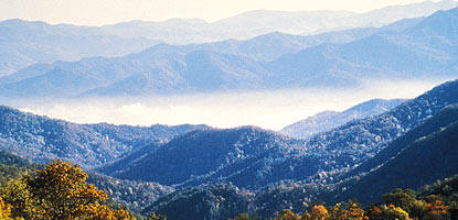
After reviewing my last few blogs, i realized that I have not written much about areas in the central United States. After I heard about the Great Smoky Mountains National Park, I realized that I had to look into it for backpacking. The first thing that I noticed about the park were the beautiful mountain landscapes and very interesting hiking trails. For people interested in backcountry backpacking, there are over 100 camping locations located throughout the park specifically for those interested in this type of experience. This Map gives a pretty good idea of the locations of the campgrounds and trails between them. One thing to note, there are a few that require reservations up to a month in advance which can be made by calling the Backcountry Reservation Office at (865) 436-1231.
An interesting hike that I found through backpacker.com is a moderate hike (about 9 miles) to rainbow falls and then to the top of Mt. LeConte. Rainbow falls is an 80 ft. waterfall, the tallest in this park, and is named for the rainbows it creates when the sun shines through the mist. The trail sounds like it is of moderate difficulty with a few boulders to climb through, but for the most part it does not seem too hard to navigate. I would definately consider taking this hike up to see one of the highest peaks in this park. I found a video that shows the top of the mountain and the lodge located there.
Rainbow Falls

I think that the Great Smoky Mountains look like a great place to go backpacking in some moderate difficulty mountains. This would be a great hike for someone that is not quite ready to embark up the Rocky Mountains, but would like to experience hiking a mountain. There are many featured trails that I did not even write about, but you can find all the info about them on the national park website. Enjoy!
Thursday, November 20, 2008
Appalachian National Scenic Trail, ME to GA

This national park is different because it extends from Maine to Georgia through all the states in between. There are many areas to hike this trail and each of them provide a different feel to backpacking. This link provides access to a great map that shows the trail in detail all the way from Maine to Georgia. This summer I did an internship in Connecticut right near the Appalachian Trail and unfortunatley i did not know how close it came to the area I was living. I would have loved to go and hike around for a day or two and discover what the trail had to offer. A nice thing about the Appalachian trail is that it is free to hike for anybody that is interested. There are fees for camping that vary by the site you choose to set up, and usually the fees are pretty small.
When doing some research on the Appalachian trail, I found out that they have a 2000 mile hike that some serious backpackers participate in. The average hiker that does the trail in one straight shot will take about 6 months to complete the journey. This is something that I would love to do, but I don't think I would be able to fit that into my schedule with work and school. This website gives information about when to start and in which direction to start the travel. There are advantages to starting from the north and from the south, so it really depends on which type of hiker you are. This spectacular feat takes long hours of endurance and perseverance, but it all pays off in the end when you reach the 2000 mile mark. In 2007 only 500 people completed this, so it is a very rare accomplishment, but something that should be congratulated.
 The Appalachian Trail provides lots of fun backpacking experiences for the weekend backpacker through the serious 2000 mile backpacker. If anyone has taken a hike down the trail, i would love to hear your experiences. Feel free to comment on this post. Until next time...happy backpacking.
Tuesday, November 18, 2008
Shawnee State Forest, OH

The area that is designated for backpacking seems to be very unique. There are no motor vehicles allowed so it is one of the best places to find peace and quiet and get out to see wildlife. I read a blog of a few people that hiked this trail and they seemed to like it very much. It sounds like they did not take the hiking very rigorously, but they were still able to hike a large portion of the trail.
While reading about the park, I found out that there was a large ice storm in 2003 that killed alot of the trees and left damage that is still seen today. Many limbs were knocked down and full trees killed from the large sheets of ice that covered the park. After about a year all of the park was cleaned up to the public, but many of the dead trees had to be logged. According to what I have read, this logging is completed and the park is back in full operation. You can still see some damage to trees if you look closeley, and the forests are a bit thinner in general, but it seems like the ice storm has been taken care of for the most part. This picture shows the damage done to a home in the nearby shawnee township:

I think this would be a great park to visit and go backpacking through for a few days. There are some beautiful hills and colors in this area, especially when it is fall time. Have a great time backpacking out there!
Wednesday, November 12, 2008
Lets take a break....
We are currently rounding the half way point of my blogs for class so I thought I would take a moment to recap what we've talked about and tell you where I'm going with this blog. I started talking about a few trips that I've gone on and really enjoyed. I then started talking about trips that I've heard about or places that I've been hoping to visit for a long time, and just have never had the chance. I have now been transitioning to a point where I am searching for your favorite places to go backpacking and camping. I have read some other blogs and reviews and will be compiling what I think are some of the best reviews I've read. I will also be looking through the national park website to see their highlighted parks and what they recommend as places for backcountry backpacking.
Thanks for following my blogging so far, and I hope you continue to stay interested as I keep writing about my favorite places to go camping.
-seth
Thanks for following my blogging so far, and I hope you continue to stay interested as I keep writing about my favorite places to go camping.
-seth
Monday, November 10, 2008
Yellowstone, WY

One of the great trails within Yellowstone National Park is the Black Canyon Trail. This trail comes as a recommendation from my friend Jenna who hiked the trail during the Summer of 2007. She told me that the trail was about 18 miles long and took their group about 2 days to complete. There are plenty of spots along the trail to set up a tent and camp for the night, making it a great weekend experience. The trail starts 5 miles east of Mammoth Hot Springs on the way to Towerr Junction. The trail begins with some meadows and prairies, but eventually hits some rocky difficult terrain.
Along the trail, there is one 15 foot waterfall that supposedly makes quite the roar as you are passing near it. According to the Yellowstone Backpacking Guide, there are some great side hikes around the Yellowstone river that you can take if you would like to venture off the beaten path. Eventually the trail winds up outside the park in Gardiner MT where you can either turn around and head back, or catch a ride back to the trailhead.

There are many other parks in Yellowstone that you should feel free to discover, but this is one that has come to me highly recommended by a friend. I have posted a few pictures to give you an idea of the beauty this trail has to offer.
Tuesday, October 21, 2008
Glen Caynon, UT

This park is probably the one that has the greatest temperature variance throughout the year. During the winter, Glen Canyon can reach temperatures of -20 all the way up to 110 in the midst of the summer months. This can create some very harsh conditions for backpacking, so there are only a few months in the spring and fall that would be ideal times to visit this national park. This is a very large park with over 1.2 million acres covered in the Utah desert. One of the places of interest within the park are the Orange Cliffs, considered by many to be one of the most scenic areas of the Colorado Plateau region. Information on the Orange Cliffs and the backcountry permits that can be obtained is found on the National Park's Website.
A fun activity to take part in at Glen Canyon is kayaking in the Lake Powell area. This provides a different way of traveling down the canyon and enjoying the beauty that it has to offer. There are few rapids and whitewater portions of the lake/river, so being prepared with safety gear is necessary.
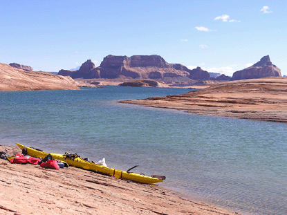 This is one place that I wish to visit some day as a day hike or a short backpacking trip. I don't think I could stay for too long because the climate is a bit unstable. The wide range of activities including, but not limited to, backpacking, hiking, kayaking, fishing, boating, and mountain biking would be very fun to take part in. This park is very interesting and I am excited to hear if any of you have been to this park. Talk to you soon!
Sunday, October 19, 2008
Olympic National Park, WA
 I think this park takes the cake on the diversity of environments and types of activities to take part in. Olympic National Park is located right in the tip of the northwest corner of the continental United states. Olympic offers beaches and trails along the coastline of the pacific ocean, forests with enormous trees and rushing rivers, and snowy mountain peaks for the adventurous climber. I had never heard about Olympic National park until I began working on this project of finding the top 20 backpacking locations. Based on the wide array of climates and conditions, i figured that it had to make my list.

Trip planning would be necessary for a trip like this. The website for this park offers some trails and possible campgrounds to use depending on which part of the park you are interested in hiking. This park, along with many in the US, has had issues with bears taking food from campers so they have installed bear wires in many of the campsites to help with hanging food out of reach of a bear. I think this site has some very clever ideas for backpacking and planning trips. I would check out as many sites as possible and read reviews in forums of places like http://www.backpacker.com/ and http://www.backpacking.net/ to feel more comfortable in places like the Olympic National Park Wilderness.

I think Olympic National Park would be a great place to explore the pacific northwest. It offers so many types of climates that It would be hard for me to narrow it down when choosing my route. If anyone has been to this this location, I would love to hear from you and about your experiences.
Friday, October 17, 2008
Porcupine Mountains, MI
A nice park in the Midwest for those that don't want to drive a long distance may be the Porcupine Mountains State Park in Michigan. This is one of the largest wilderness locations in the Midwest totalling about 60.000 square acres. The park offers opportunities for all types of visitors with activities including: skiing, hiking, canoeing, biking, and of course, backpacking. The backpacking trails are numerous, with over 90 miles available for use within the wilderness area. While backpacking, you may encounter one or more of the four lakes located within the park. The waters from the lakes eventually merge together and rush through waterfalls and rapids to lake superior.

I read a review on this park from another blogger who said it is the only backpacking trip where he has been kept up at night by a black bear trying to get to his food. This is a tip to remember that you should ALWAYS hang your food in a bear bag or some other type of container to keep bears out. Make sure to hang it over 100 feet from your campground and at least 20 ft. off the ground. Keep all food and scented items (toothpaste, soap, deodorant) in the bag for your own protection.

For the best backpacking options, check out this link to the map of the park.
Thursday, October 16, 2008
Mount Rainier, WA

On the complete opposite end of the country of my last post is a mountain known to many in the backpacking community. Mt. Rainier is located in the state of Washington only about 100 miles from Seattle. One of the pinnacle trails of Mt. Rainier National Park is the Wonderland trail, encircling the entire mountain, 93 miles long. This is a very strenuous hike with lot's of elevation gains as displayed by this graphic. I think this hike would take at least a week if you would like to do any resting or side hikes, something that would be necessary to take in all the beauty that Mt. Rainer has to offer.

In order to get a reservation for a back country permit, go to the National Parks Website. There are first come, first serve permits available, but if you are going to plan a trip, it would be safe to place a reservation around March 15th in order to have a better chance of guaranteeing a permit. You must submit your plan on the Wonderland trail including the campgrounds that you will be sleeping at each night. The following is a list of the campgrounds and the elevations they are located at along the trail:
Devil's Dream- 5,060 feet
South Puyallup River- 4,000 feet
Klapatche Park- 5,515 feet
North Puyallup River- 3,750 feet
Golden Lakes- 5,130 feet
South Mowich River- 2,605 feet
Mowich Lake Campground- 4,929 feet
Ipsut Creek Campground- 2,330 feet
Carbon River- 3,195 feet
Dick Creek- 4,185 feet
Mystic Camp- 5,570 feet
Granite Creek- 5,765
Sunrise Camp- 6,245
White River Campground- 4,280 feet
Summerland- 5,940 feet
Indian Bar- 5,120 feet
Nickel Creek- 3,385 feet
Maple Creek- 2,815 feet
Paradise River- 3,805 feet
Cougar Rock Campground- 3,180 feet
For the very adventurous backpacker, there are climbing options within the park adding a challenge and fun aspect to the hike. Reservations for these must also be made at the park website when planning your trip. This site makes my list of the top 20 places to backpack in the US because of the grandeur of the mountain and challenge that the Wonderland trail provides.
Appalachian Trail, NH
The Appalachian mountains provide some of the greatest mountain landscapes in the United States. I have traveled through the mountains a few times, and every time I am in awe of the views and sights they have to offer. I have never backpacked through these mountains, but I have found a trail that I would love to visit some day. Nestled in the northeastern corner of the United States is a trail that i found through a community I am involved in at backpacker.com. The trail starts in New Hampshire and goes about 28 miles, winding up in Maine. The trail offers many lookout points and neat landscapes that are among none other. Here are a few pictures from some people on backpacker.com:


The trail is quite strenuous according to backpacker.com and the pictures that they have provided. I feel like it would all be worth it when you find small lakes within the mountains and all the wildlife surrounding you on your hike through the wilderness. I am not sure what this location has for camping opportunities. The backpacker website has a few locations of small cabin's and other campgrounds listed, along with their corresponding GPS coordinates along the trail. This would be a great hike to spread over a few days because of the tough nature of the trail. I hope that someday I can head out to the Appalachian Mountains and do some hiking on this trail or something similar. If you have experiences in this area, feel free to share them in the comments section. See ya out there!

Wednesday, October 8, 2008
Denali National Park, AK

Denali National Park is currently on the top of my list of places I want to travel to and do some hiking and backpacking. I have never been to Alaska but hope to go very soon. From what I have read and heard, Denali National Park offers some of the best chances to see wildlife in the US because of it's secluded location, far from any civilization. I have done alot of reading on the backcountry passes for Denali and I am very inspired to try and obtain one some day. With the backcountry pass, you plan your trip based on maps from the park and are free to hike anywhere in the park you would like. At night, you need to camp in designated areas, but they are far from other people giving you a very secluded feeling.
The wildlife in Denali is spectacular with over thirty nine species of mammals documented so far. The park outlines "The Big Five" mammals that people want to see when they visit.
They are:
Moose
Moose
Caribou
Dall Sheep
Wolf
Grizzly Bear
Dall Sheep
Wolf
Grizzly Bear


One of the things they talk about extensively at Denali is the amount of bears located within the park. Backpackers need to be aware of the Grizzly Bears and use protective containers for their food, and practice bear safety techniques while hiking. Bears are just as scared of us as we are of them, so the the National park website outlines a few ways to make sure hikers don't encounter bears.
This is one of the parks that I most look forward to backpacking, let me know if you have had any great experiences here!
Thursday, September 25, 2008
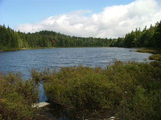
Boundary Waters, MN
Located in northern Minnesota, the boundary waters is one of my favorite places I have been for canoeing and backpacking. There are over 70 entry points into the Boundary Waters Canoe Area Wilderness (BWCAW). Most of these entry points are on lakes or rivers connected by narrow water ways or trails for portaging. Each point is unique with a wide range of difficulty levels. All of the entry points are listed on the BWCA Website along with difficulty ratings and how to get there. On BWCAWiki.com, there are reviews of many of the entry points, and details about fishing, camping, and how to get to individual lakes.

I have entered on the Echo Trail at entry point #14 and had an amazing experience. The trip started with a 40 rod portage from the parking area down to the river. Traveling up the river was a great time, seeing some great scenic landscapes and wildlife along the way. One of the things that I really like about the BWCAW is the fact that there are only about 3-4 designated camping areas on each lake, thus providing a solemn and tranquil place to pitch a tent. My group found a great spot right on Upper Pauness Lake and set up camp. We were there for a few days and had a great time taking a day trip to the Canadian border, eating lunch on the Canadian waters.
The BWCAW has many backpacking opportunities as well and many people love the chance to take a side trip going deep into the wilderness. I would highly suggest taking a trip to the BWCAW if you would like to get out into some of the most serene woods left untouched by man.

Tuesday, September 16, 2008
Grand Canyon, AZ

Nestled deep within the walls of the Grand Canyon lies a small village named Supai. The Indian people of the Supai reservation discovered early on that they are live in an area where tourism would thrive. Even though the main source of income is tourism (http://www.havasupaitribe.com/aboutus.html), I have always felt that this is a place to get away from the busyness of life and relax while taking in some beautiful sights.
The hike in to the village is eight miles starting off with about two miles of steep switchbacks into the canyon. After this it is an easy hike down to the village. The village is home to about 450 members of the 650 member Havasupai tribe (http://www.desertusa.com/mag06/sep/supai.html). It is very interesting to walk through this village and see the homes and businesses that have been established in this very poor community. An interesting fact about Supai is that it is the only place in the US that still has the U.S. Postal Service deliver mail via pack mules. After the village there is a two mile hike to the campgrounds, and the waterfalls of the Havasu creek.

The translation of Havasupai is "People of the Blue-Green Waters." I think this is a fitting name for a place with one of the most photographed waterfalls in the world. Havasu falls is a drop of about 100 feet to multiple pools of the famous blue green waters. Mooney falls is about two miles downstream and drops 200 feet. These falls are part of the main draw for backpackers and photographers. The Havasu Indian reservation has a special place in my heart because of the serenity and rest that it offers. I can't wait until I have the chance to return some day.

Hey!
Welcome to "Just Go Backpacking...." This site is intended to provide some useful information on the top 20 or so places to go backpacking in the U.S. I have been to a few of these sites and others have been visited by friends of mine. I hope this provides some useful information for those that are interested in planning a backpacking trip to one of our fine locations here in the United States. Enjoy!
Subscribe to:
Posts (Atom)